Přeskočit na obsah

Soubor:WestBengalDistricts numbered.svg

Obsah stránky není podporován v jiných jazycích.
Z Wikipedie, otevřené encyklopedie

Původní soubor (soubor SVG, nominální rozměr: 768 × 1 159 pixelů, velikost souboru: 311 KB)

Popis

Popis
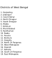
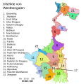
English: Original summary by creator of base svg file deeptrivia. Districts of West Bengal

Based on https://web.archive.org/web/20040606103522/www.censusindia.net/results/2001maps/wbengal01.html

Modifications by Mouryan:

  1. upladed translated version of File:WestBengalDistricts numbered de.svg.
  2. The districts of Dakshin 24 Parganas district and Uttar 24 Parganas were incorrectly numbered in the Map. The errors have been rectified.

Modifications by Furfur:

  1. The 4 (four) new districts of West Bengal namely Paschim Bardhaman district (bifurcated from Bardhaman district), Kalimpong district (bifurcated from Darjeeling district), Alipurduar district (bifurcated from Jalpaiguri district) and Jhargram district (bifurcated from Paschim Medinipur district) has been shown in this new Updated map.

Modifications by Antorjal:

  1. Midnapore District has been bifurcated to show both Paschim Medinipur and Purba Medinipur.
  2. Numbered and listed districts per comments at peer-review.
  3. Font size reduced for clarity, since the districts are now listed.
  4. Many of the spellings did not conform to linked articles in the text. All spellings now match the West Bengal article spellings.
Datum 8. října 2006 (datum prvotního načtení souboru)
Zdroj Na Commons přenesl z en.wikipedia uživatel Padawane.
Autor Původně soubor načetl Antorjal na projektu Wikipedie v jazyce angličtina
Další verze

[editovat]

SVG vývoj
InfoField
 
Zdrojový kód tohoto SVG není validní.
 
Tento vektorový obrázek byl vytvořen programem Adobe Illustrator,
 
and with Inkscape.
 
 This map uses embedded text that can be easily translated using a text editor.

Licence

w:cs:Creative Commons
uveďte autora zachovejte licenci
Tento soubor podléhá licenci Creative Commons Uveďte autora-Zachovejte licenci 2.5 Generic, 2.0 Generic a 1.0 Generic.
Dílo smíte:
  • šířit – kopírovat, distribuovat a sdělovat veřejnosti
  • upravovat – pozměňovat, doplňovat, využívat celé nebo částečně v jiných dílech
Za těchto podmínek:
  • uveďte autora – Máte povinnost uvést autorství, poskytnout odkaz na licenci a uvést, pokud jste provedli změny. Toho můžete docílit jakýmkoli rozumným způsobem, avšak ne způsobem naznačujícím, že by poskytovatel licence schvaloval nebo podporoval vás nebo vaše užití díla.
  • zachovejte licenci – Pokud tento materiál jakkoliv upravíte, přepracujete nebo použijete ve svém díle, musíte své příspěvky šířit pod stejnou nebo slučitelnou licencí jako originál.
w:cs:Creative Commons
uveďte autora zachovejte licenci
Tento soubor podléhá licenci Creative Commons Uveďte autora-Zachovejte licenci 3.0 Unported. Subject to disclaimers.
Dílo smíte:
  • šířit – kopírovat, distribuovat a sdělovat veřejnosti
  • upravovat – pozměňovat, doplňovat, využívat celé nebo částečně v jiných dílech
Za těchto podmínek:
  • uveďte autora – Máte povinnost uvést autorství, poskytnout odkaz na licenci a uvést, pokud jste provedli změny. Toho můžete docílit jakýmkoli rozumným způsobem, avšak ne způsobem naznačujícím, že by poskytovatel licence schvaloval nebo podporoval vás nebo vaše užití díla.
  • zachovejte licenci – Pokud tento materiál jakkoliv upravíte, přepracujete nebo použijete ve svém díle, musíte své příspěvky šířit pod stejnou nebo slučitelnou licencí jako originál.
Tato licenční šablona byla k tomuto souboru přidána v rámci změny licencování.
GNU head Tento dokument smí být kopírován, šířen nebo upravován podle podmínek Svobodné licence GNU pro dokumenty verze 1.2 nebo libovolné vyšší verze publikované nadací Free Software Foundation. Dokument nemá neměnné části ani texty na předním či zadním přebalu. Kopie textu licence je k dispozici v oddíle nazvaném GNU Free Documentation License. Subject to disclaimers.

Původní historie souboru

Původní stránka s popisem souboru byla zde. Všechna následující uživatelská jména odkazují na projekt en.wikipedia.
  • 2006-12-25 04:28 Deeptrivia 450×500×0 (102714 bytes) Repair attempt
  • 2006-12-25 04:17 Deeptrivia 450×500×0 (101044 bytes) Repair attempt
  • 2006-10-08 14:21 Antorjal 450×500×0 (100501 bytes) Original summary by creator of base svg file [[User:deeptrivia|deeptrivia]]. Districts of West Bengal Based on http://web.archive.org/web/20040606103522/www.censusindia.net/results/2001maps/wbengal01.html Modifications by [[User:Antorjal|An
  • 2006-10-08 14:17 Antorjal 450×500×0 (100294 bytes) Original summary by creator of base svg file [[User:deeptrivia|deeptrivia]]. Districts of West Bengal Based on http://web.archive.org/web/20040606103522/www.censusindia.net/results/2001maps/wbengal01.html Modifications by [[User:Antorjal|An
  • 2006-10-08 14:15 Antorjal 450×500×0 (100501 bytes) Original summary by creator of base svg file [[User:deeptrivia|deeptrivia]]. Districts of West Bengal Based on http://web.archive.org/web/20040606103522/www.censusindia.net/results/2001maps/wbengal01.html Modifications by [[User:Antorjal|An
  • 2006-10-08 14:09 Antorjal 450×500×0 (100484 bytes) Original summary by creator of base svg file [[User:deeptrivia|deeptrivia]]. Districts of West Bengal Based on http://web.archive.org/web/20040606103522/www.censusindia.net/results/2001maps/wbengal01.html Modifications by [[User:Antorjal|An
  • 2006-10-08 14:05 Antorjal 450×500×0 (100501 bytes) Original summary by creator of base svg file [[User:deeptrivia|deeptrivia]]. Districts of West Bengal Based on http://web.archive.org/web/20040606103522/www.censusindia.net/results/2001maps/wbengal01.html Modifications by [[User:Antorjal|An

Popisky

Přidejte jednořádkové vysvětlení, co tento soubor představuje

Položky vyobrazené v tomto souboru

zobrazuje

Historie souboru

Kliknutím na datum a čas se zobrazí tehdejší verze souboru.

Datum a časNáhledRozměryUživatelKomentář
současná25. 4. 2020, 23:04Náhled verze z 25. 4. 2020, 23:04768 × 1 159 (311 KB)Debjitpaul10Updated text
25. 4. 2020, 22:45Náhled verze z 25. 4. 2020, 22:45768 × 1 159 (113 KB)Debjitpaul10Uploaded a corrected and transparent version.
5. 11. 2017, 08:15Náhled verze z 5. 11. 2017, 08:15576 × 601 (144 KB)Mouryan{{Information |Description={{en|Original summary by creator of base svg file deeptrivia. Districts of West Bengal Based on http://web.archive.org/web/20040606103522/www.censusindia.net/results/2001maps/wbengal01.html Modificati...
5. 11. 2017, 04:51Náhled verze z 5. 11. 2017, 04:51576 × 601 (144 KB)Mouryan{{Information |Description={{en|Original summary by creator of base svg file deeptrivia. Districts of West Bengal Based on http://web.archive.org/web/20040606103522/www.censusindia.net/results/2001maps/wbengal01.html Modificati...
25. 11. 2008, 15:59Náhled verze z 25. 11. 2008, 15:591 595 × 2 256 (212 KB)GDibyendu{{Information |Description=fixed map (sunderbans), fixed district names |Source=based on locator map:West_Bengal_locator_map.svg |Date=2008-11-25 |Author=GDibyendu |Permission=All |other_versions= }}
24. 11. 2008, 22:30Náhled verze z 24. 11. 2008, 22:30450 × 500 (100 KB)GDibyenduReverted to version as of 14:58, 17 January 2008 as some error crept in today's attempted upload
24. 11. 2008, 22:14Náhled verze z 24. 11. 2008, 22:141 595 × 2 256 (191 KB)GDibyendu{{Information |Description=Corrected the map (it was not showing sunderbans are properly) |Source=This map is based on locator map of West Bengal (West_Bengal_locator_map.svg) |Date=2008-11-24 |Author=GDibyendu |Permission=All |other_versions= }}
22. 11. 2008, 19:43Náhled verze z 22. 11. 2008, 19:43450 × 500 (100 KB)GDibyenduReverted to version as of 14:58, 17 January 2008
22. 11. 2008, 19:41Náhled verze z 22. 11. 2008, 19:41450 × 500 (7 KB)GDibyendu{{Information |Description=Rewrote text in image to improve readability |Source=Based on last version |Date=2008-11-22 |Author=GDibyendu |Permission=All |other_versions= }}
17. 1. 2008, 16:58Náhled verze z 17. 1. 2008, 16:58450 × 500 (100 KB)File Upload Bot (Magnus Manske) {{BotMoveToCommons|en.wikipedia}} {{Information |Description={{en|Original summary by creator of base svg file deeptrivia. Districts of West Bengal Based on http://web.archive.org/web/20040606103522/www.censusindia.net/results/200

Tento soubor nepoužívá žádná stránka.

Globální využití souboru

Tento soubor využívají následující wiki:

Zobrazit další globální využití tohoto souboru.

Metadata