
Soubor:Possible definitions of the boundary between Europe and Asia.png
Původní soubor (729 × 1 129 pixelů, velikost souboru: 207 KB, MIME typ: image/png)
| Tento soubor pochází z Wikimedia Commons. Níže jsou zobrazeny informace, které obsahuje jeho tamější stránka s popisem souboru. |
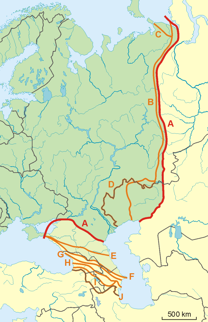
Popis
| Popis |
English: A map of possible definitions of the boundary between Asia and Europe.
Note that most of these lines are not referenced to any sources proposing them. The red line marked "A" is apparently the "Strahlenberg" definition commononly taught in Soviet-era Russia. See File:Historical Europe-Asia boundaries 1700 to 1900.png for a map which is actually based on references. The modern mainstream definition used by the UN (see also this) are marked "B" (Urals and Ural River) and "F" (Caucasus watershed). Lines C, D, E, G, H, I and J are currently without reference. Red line - "Strahlenberg" border, allegedly also used by the International Geographical Union [1]
Orange lines - other variants of border:
Polski: Mapa wariantów przebiegów granicy pomiędzy Europą a Azją
linie pomarańczowe - inne warianty przebiegu granicy:
|
| Datum | 09-04-2008 |
| Zdroj | Vlastní dílo |
| Autor | Aotearoa |
| Další verze | Image:TransAsia m.png, File:Historical Europe-Asia boundaries 1700 to 1900.png |
Licence

|
Tento dokument smí být kopírován, šířen nebo upravován podle podmínek Svobodné licence GNU pro dokumenty verze 1.2 nebo libovolné vyšší verze publikované nadací Free Software Foundation. Dokument nemá neměnné části ani texty na předním či zadním přebalu. Kopie textu licence je k dispozici v oddíle nazvaném GNU Free Documentation License. |
- Dílo smíte:
- šířit – kopírovat, distribuovat a sdělovat veřejnosti
- upravovat – pozměňovat, doplňovat, využívat celé nebo částečně v jiných dílech
- Za těchto podmínek:
- uveďte autora – Máte povinnost uvést autorství, poskytnout odkaz na licenci a uvést, pokud jste provedli změny. Toho můžete docílit jakýmkoli rozumným způsobem, avšak ne způsobem naznačujícím, že by poskytovatel licence schvaloval nebo podporoval vás nebo vaše užití díla.
- zachovejte licenci – Pokud tento materiál jakkoliv upravíte, přepracujete nebo použijete ve svém díle, musíte své příspěvky šířit pod stejnou nebo slučitelnou licencí jako originál.
Historie souboru
Kliknutím na datum a čas se zobrazí tehdejší verze souboru.
| Datum a čas | Náhled | Rozměry | Uživatel | Komentář | |
|---|---|---|---|---|---|
| současná | 14. 11. 2022, 10:34 | | 729 × 1 129 (207 KB) | Рагин1987 | Dull shade of green up to the "F" line |
| 19. 2. 2022, 15:12 |  | 729 × 1 129 (205 KB) | Lojwe | Frame removed | |
| 1. 10. 2010, 22:29 |  | 735 × 1 134 (156 KB) | Bogomolov.PL | Reverted to version as of 08:57, 9 April 2008 | |
| 1. 10. 2010, 21:44 |  | 735 × 1 134 (137 KB) | Zé Carioca~commonswiki | Trying to fix the error we are facing on the articles. | |
| 1. 10. 2010, 17:56 |  | 735 × 1 134 (137 KB) | Gvogas | Inclusion of the Miles Clark route line. (sorry for the tries, my internet gave problems). | |
| 1. 10. 2010, 17:55 |  | 735 × 1 134 (137 KB) | Gvogas | Reverted to version as of 15:52, 1 October 2010 | |
| 1. 10. 2010, 17:54 |  | 735 × 1 134 (137 KB) | Gvogas | (Inclusion of the Miles Clark route line.) | |
| 1. 10. 2010, 17:52 |  | 735 × 1 134 (137 KB) | Gvogas | Inclusion of the Miles Clark route line. | |
| 9. 4. 2008, 10:57 |  | 735 × 1 134 (156 KB) | Aotearoa | {{Information |Description=Map of Europe (green) - Asia (yellow) border. Red line (A) - border accoring to International Geographical Union and most European geographers, orange lines - other variants of border. |Source=własna praca |Date=09-04-2008 | |
Využití souboru
Globální využití souboru
Tento soubor využívají následující wiki:
- Využití na am.wikipedia.org
- Využití na ar.wikipedia.org
- Využití na arz.wikipedia.org
- Využití na az.wikipedia.org
- Využití na ba.wikipedia.org
- Využití na be.wikipedia.org
- Využití na bn.wikipedia.org
- Využití na ca.wikipedia.org
- Využití na ce.wikipedia.org
- Využití na de.wikipedia.org
- Eurasien
- Portal:Mauern und Grenzen
- Liste interkontinentaler Staaten
- Wikipedia Diskussion:WikiProjekt Geographie/Archiv/2013-1
- Wikipedia:Löschkandidaten/28. Februar 2016
- Wikipedia Diskussion:WikiProjekt Kategorien/Archiv/2016-II
- Wikipedia Diskussion:Kurier/Archiv/2017/10
- Vorlage Diskussion:Navigationsleiste Kraftwerke
- Wikipedia Diskussion:Kurier/Archiv/2022/08
- Využití na en.wikipedia.org
- Využití na et.wikipedia.org
- Využití na hr.wikipedia.org
- Kategorija:Arktičkooceanski slijev (Europa)
- Kategorija:Arktičkooceanski slijev (Azija)
- Kategorija:Mora Arktičkog oceana
- Kategorija:Reljefni oblici u Arktičkom oceanu
- Kategorija:Mora Arktičkog oceana (Azija)
- Kategorija:Mora Arktičkog oceana (Europa)
- Kategorija:Reljefni oblici u Arktičkom oceanu (Azija)
- Kategorija:Tjesnaci Arktičkog oceana (Europa)
- Kategorija:Vodene mase Arktičkog oceana (Europa)
- Kategorija:Reljefni oblici u Arktičkom oceanu (Europa)
- Kategorija:Tjesnaci Arktičkog oceana (Azija)
- Kategorija:Vodene mase Arktičkog oceana (Azija)
- Kategorija:Karsko more
- Predložak:Granica Europe i Azije
- Kategorija:Zaljevi Arktičkog oceana (Azija)
- Kategorija:Zaljevi Arktičkog oceana (Europa)
- Kategorija:Estuariji Arktičkog oceana (Azija)
- Kategorija:Estuariji Tihog oceana (Azija)
- Využití na hu.wikipedia.org
- Využití na hy.wikipedia.org
- Využití na ia.wikipedia.org
Zobrazit další globální využití tohoto souboru.