
Soubor:Pineridgereservationmap.png
Větší rozlišení není k dispozici
Pineridgereservationmap.png (493 × 379 pixelů, velikost souboru: 71 KB, MIME typ: image/png)
| Tento soubor pochází z Wikimedia Commons. Níže jsou zobrazeny informace, které obsahuje jeho tamější stránka s popisem souboru. |

|
Tento obrázek (skupina map) by měl být vytvořen pomocí vektorové grafiky jako SVG soubor. To má několik výhod; podrobnosti najdete na stránce Commons:Media for cleanup. Je-li SVG verze tohoto obrázku již k dispozici, prosím nahrajte ji. Po nahrání nahraďte tuto šablonu šablonou {{Vector version available|jméno nového obrázku.svg}}.
|
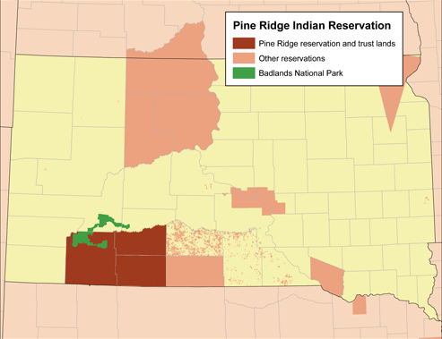
| Popis | Map of the Pine Ridge Indian Reservation. |
| Datum | |
| Zdroj | Vlastní dílo (Původní text: „Self-made using the National Atlas.“) |
| Autor | Kmusser |
Licence
Kmusser, držitel autorských práv k tomuto dílu, ho tímto zveřejňuje za podmínek následující licence:
Tento soubor podléhá licenci Creative Commons Uveďte autora-Zachovejte licenci 2.5 Generic
Uveďte autora: Kmusser
- Dílo smíte:
- šířit – kopírovat, distribuovat a sdělovat veřejnosti
- upravovat – pozměňovat, doplňovat, využívat celé nebo částečně v jiných dílech
- Za těchto podmínek:
- uveďte autora – Máte povinnost uvést autorství, poskytnout odkaz na licenci a uvést, pokud jste provedli změny. Toho můžete docílit jakýmkoli rozumným způsobem, avšak ne způsobem naznačujícím, že by poskytovatel licence schvaloval nebo podporoval vás nebo vaše užití díla.
- zachovejte licenci – Pokud tento materiál jakkoliv upravíte, přepracujete nebo použijete ve svém díle, musíte své příspěvky šířit pod stejnou nebo slučitelnou licencí jako originál.
Historie souboru
Kliknutím na datum a čas se zobrazí tehdejší verze souboru.
| Datum a čas | Náhled | Rozměry | Uživatel | Komentář | |
|---|---|---|---|---|---|
| současná | 6. 11. 2019, 23:09 | | 493 × 379 (71 KB) | Kmusser | crop and add the rest of Bennett county |
| 19. 3. 2008, 19:57 |  | 500 × 387 (82 KB) | Kmusser | added Badlands | |
| 19. 3. 2008, 19:43 |  | 500 × 389 (79 KB) | Kmusser | {{Information |Description=Map of the Pine Ridge Indian Reservation. |Source=Self-made using the National Atlas. |Date=March 19,2008 |Author= Kmusser |Permi |
Využití souboru
Tento soubor používá následující stránka:
Globální využití souboru
Tento soubor využívají následující wiki:
- Využití na ar.wikipedia.org
- Využití na ca.wikipedia.org
- Využití na de.wikipedia.org
- Využití na en.wikipedia.org
- Využití na eo.wikipedia.org
- Využití na fr.wikipedia.org
- Využití na gl.wikipedia.org
- Využití na nl.wikipedia.org
- Využití na pl.wikipedia.org
- Využití na uk.wikipedia.org
- Využití na www.wikidata.org