
Soubor:Petsamo.png

Velikost tohoto náhledu: 507 × 599 pixelů. Jiná rozlišení: 203 × 240 pixelů | 406 × 480 pixelů.
Původní soubor (800 × 945 pixelů, velikost souboru: 30 KB, MIME typ: image/png)
| Tento soubor pochází z Wikimedia Commons. Níže jsou zobrazeny informace, které obsahuje jeho tamější stránka s popisem souboru. |
| Popis |
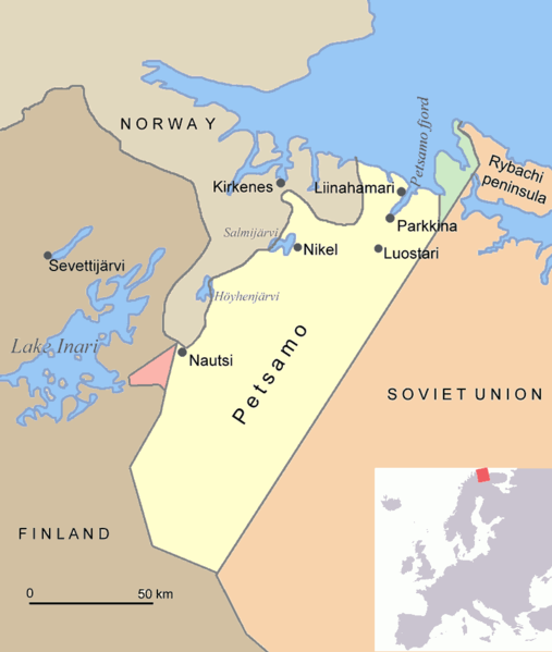
English: Map of Petsamo area in northern Finland/Soviet Union/Russia. The green area is the Finnish part of the Rybachi peninsula (Kalastajasaarento) which was ceded to the Soviet Union after the Winter War. The red area is the Jäniskoski-Niskakoski area ceded to the Soviet Union in 1947. |
| Zdroj | Vlastní dílo |
| Autor | Jniemenmaa |
Já, držitel autorských práv k tomuto dílu, ho tímto zveřejňuji za podmínek následujících licencí:

|
Tento dokument smí být kopírován, šířen nebo upravován podle podmínek Svobodné licence GNU pro dokumenty verze 1.2 nebo libovolné vyšší verze publikované nadací Free Software Foundation. Dokument nemá neměnné části ani texty na předním či zadním přebalu. Kopie textu licence je k dispozici v oddíle nazvaném GNU Free Documentation License. |
| Tento soubor podléhá licenci Creative Commons Uveďte autora-Zachovejte licenci 3.0 Unported | ||
| ||
| Tato licenční šablona byla k tomuto souboru přidána v rámci změny licencování. |
Můžete si zvolit libovolnou z těchto licencí.

|
Tento obrázek (skupina map) by měl být vytvořen pomocí vektorové grafiky jako SVG soubor. To má několik výhod; podrobnosti najdete na stránce Commons:Media for cleanup. Je-li SVG verze tohoto obrázku již k dispozici, prosím nahrajte ji. Po nahrání nahraďte tuto šablonu šablonou {{Vector version available|jméno nového obrázku.svg}}.
|
Historie souboru
Kliknutím na datum a čas se zobrazí tehdejší verze souboru.
| Datum a čas | Náhled | Rozměry | Uživatel | Komentář | |
|---|---|---|---|---|---|
| současná | 17. 6. 2015, 21:08 | | 800 × 945 (30 KB) | Hohum | Clearer |
| 1. 8. 2005, 19:48 |  | 800 × 945 (70 KB) | Jniemenmaa | Map of Petsamo area in northern Finland/Soviet Union/Russia. The green area is the Finnish part of the Rybachi peninsula which was ceded to the Soviet Union after the Winter War. The Red area is the Jäniskoksi area ceded to the SU some years after the C |
Využití souboru
Tento soubor používají následující 3 stránky:
Globální využití souboru
Tento soubor využívají následující wiki:
- Využití na ar.wikipedia.org
- Využití na ba.wikipedia.org
- Využití na ca.wikipedia.org
- Využití na da.wikipedia.org
- Využití na de.wikipedia.org
- Využití na en.wikipedia.org
- Central European Time
- User:Jniemenmaa/images
- Rybachy Peninsula
- Walter Schuck
- Heinrich Bartels
- Pechengsky District
- Jakob Norz
- Operation EF (1941)
- Norway–Russia border
- Rudi Linz
- August Mors
- Jäniskoski-Niskakoski territory
- User:Falcaorib/Russia and Soviet Union
- User:Falcaorib/Sweden and Finland
- Friedrich-Wilhelm Strakeljahn
- Využití na eo.wikipedia.org
- Využití na es.wikipedia.org
- Využití na eu.wikipedia.org
- Využití na fi.wikipedia.org
- Využití na fr.wikipedia.org
- Využití na gl.wikipedia.org
- Využití na hu.wikipedia.org
- Využití na it.wikipedia.org
- Využití na nl.wikipedia.org
- Využití na nn.wikipedia.org
Zobrazit další globální využití tohoto souboru.