
Soubor:Methane Clathrate Location Map USGS.gif
Větší rozlišení není k dispozici
Methane_Clathrate_Location_Map_USGS.gif (363 × 274 pixelů, velikost souboru: 19 KB, MIME typ: image/gif)
| Tento soubor pochází z Wikimedia Commons. Níže jsou zobrazeny informace, které obsahuje jeho tamější stránka s popisem souboru. |
Popis

|
Tento obrázek (skupina map) by měl být vytvořen pomocí vektorové grafiky jako SVG soubor. To má několik výhod; podrobnosti najdete na stránce Commons:Media for cleanup. Je-li SVG verze tohoto obrázku již k dispozici, prosím nahrajte ji. Po nahrání nahraďte tuto šablonu šablonou {{Vector version available|jméno nového obrázku.svg}}.
|
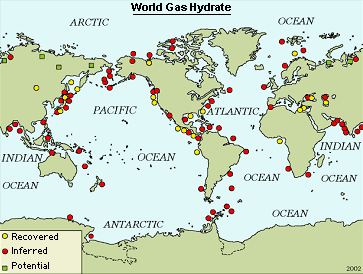
| Popis |
English: Locations of known and inferred gas hydrate (methane clathrate) occurrences in oceanic sediments of outer continental margins and permafrost regions. Deutsch: Bekannte und vermutete Lagerstätten von Methanhydrat an den Kontinentalrändern und in Permafrostböden. |
| Zdroj | [1] |
| Autor | U.S. Geological Survey |
| Další verze |
 |
Licence
Tento soubor je volné dílo, protože obsahuje materiály pocházející od United States Geological Survey (USGS), agentury Ministerstva vnitra USA. Pro bližší informaci vizte oficiální licenční pravidla USGS (anglicky).
|
Historie souboru
Kliknutím na datum a čas se zobrazí tehdejší verze souboru.
| Datum a čas | Náhled | Rozměry | Uživatel | Komentář | |
|---|---|---|---|---|---|
| současná | 12. 4. 2007, 21:50 | | 363 × 274 (19 KB) | Eintragung ins Nichts | {{Information |Description=Locations of known and inferred gas hydrate (methane clathrate) occurrences in oceanic sediments of outer continental margins and permafrost regions. |Source=[http://energy.usgs.gov/other/gashydrates/] |Date= |Author=U.S. Geolo |
Využití souboru
Tento soubor používá následující stránka:
Globální využití souboru
Tento soubor využívají následující wiki:
- Využití na be.wikipedia.org
- Využití na de.wikipedia.org
- Využití na en.wikipedia.org
- Využití na pl.wikipedia.org
- Využití na pt.wikipedia.org
- Využití na ru.wikipedia.org
- Využití na uk.wikipedia.org