
Soubor:Lordship of Mecklenburg locator map (1250).svg

Velikost tohoto PNG náhledu tohoto SVG souboru: 761 × 600 pixelů. Jiná rozlišení: 305 × 240 pixelů | 609 × 480 pixelů | 975 × 768 pixelů | 1 280 × 1 008 pixelů | 2 560 × 2 017 pixelů | 990 × 780 pixelů.
Původní soubor (soubor SVG, nominální rozměr: 990 × 780 pixelů, velikost souboru: 3,14 MB)
| Tento soubor pochází z Wikimedia Commons. Níže jsou zobrazeny informace, které obsahuje jeho tamější stránka s popisem souboru. |
Popis
Tento vektorový obrázek byl vytvořen programem Inkscape .
| Popis |
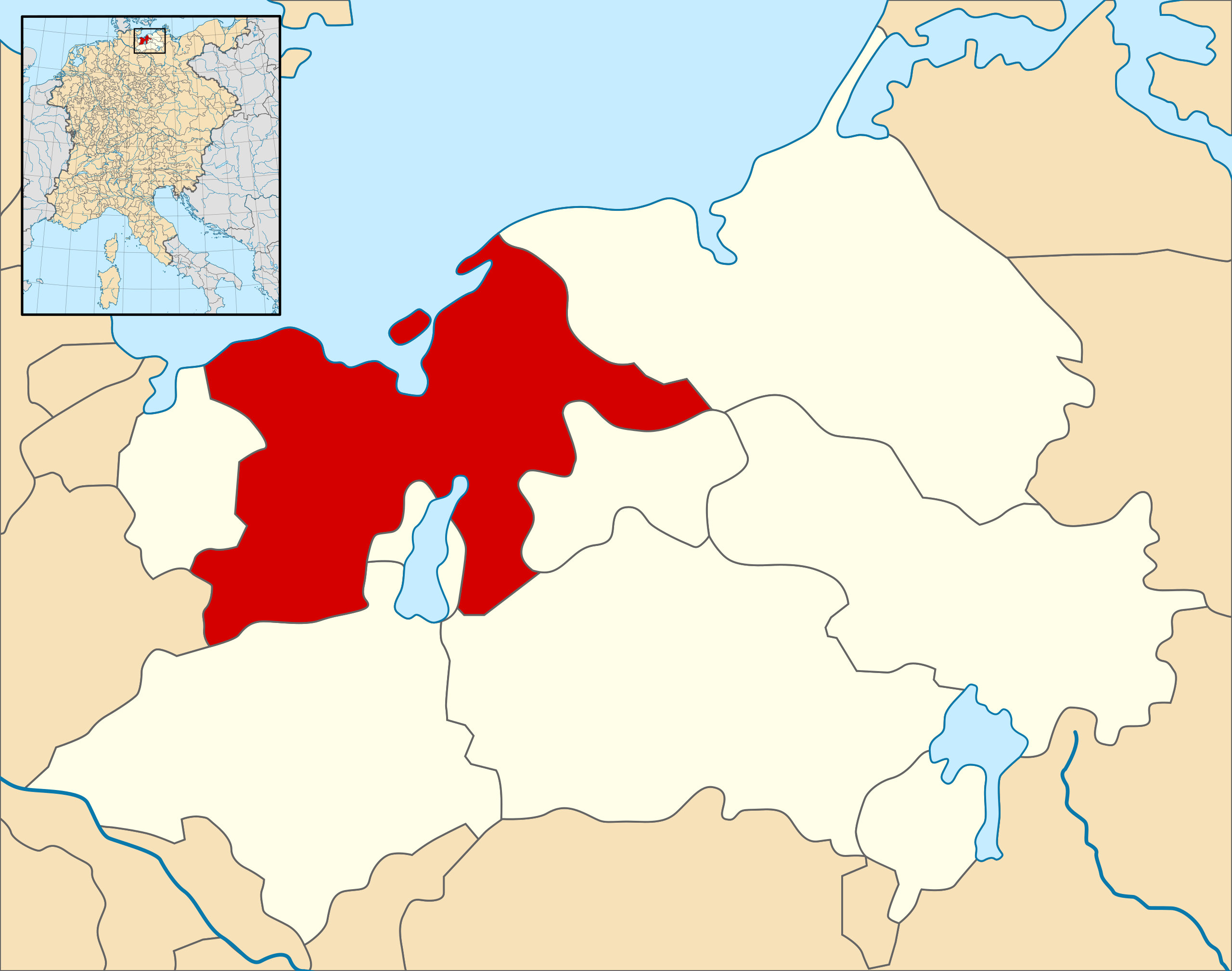
English: A map of the Lordship of Mecklenburg (German: Herrschaft Mecklenburg) (red) at the time of the Hohenstaufen Emperors (circa 1250).
The highlighted area shows the territories that would later become the Duchy of Mecklenburg (with the exception of Strelitz/Stargard, which were still part of the Margraviate of Brandenburg at this point in history). Note that while it uses the same scheme as standard location/locator maps, this map technically does not conform to the standard, as it is not in equirectangular projection. Therefore grid lines for latitude and longitude are also included on the sub-map. |
| Datum | |
| Zdroj |
File: own work Data: Droysens-26.jpg |
| Autor | Alphathon /ˈæɫfə.θɒn/ (talk) |
| Další verze |
.svg) |
.svg)
.svg)
.svg)
.svg)
.svg)
.svg)
.svg)

.svg)
Licence
Tento soubor podléhá licenci Creative Commons Uveďte autora-Zachovejte licenci 4.0 International
- Dílo smíte:
- šířit – kopírovat, distribuovat a sdělovat veřejnosti
- upravovat – pozměňovat, doplňovat, využívat celé nebo částečně v jiných dílech
- Za těchto podmínek:
- uveďte autora – Máte povinnost uvést autorství, poskytnout odkaz na licenci a uvést, pokud jste provedli změny. Toho můžete docílit jakýmkoli rozumným způsobem, avšak ne způsobem naznačujícím, že by poskytovatel licence schvaloval nebo podporoval vás nebo vaše užití díla.
- zachovejte licenci – Pokud tento materiál jakkoliv upravíte, přepracujete nebo použijete ve svém díle, musíte své příspěvky šířit pod stejnou nebo slučitelnou licencí jako originál.
Historie souboru
Kliknutím na datum a čas se zobrazí tehdejší verze souboru.
| Datum a čas | Náhled | Rozměry | Uživatel | Komentář | |
|---|---|---|---|---|---|
| současná | 9. 5. 2016, 17:09 | | 990 × 780 (3,14 MB) | Alphathon | == {{int:filedesc}} == {{Inkscape}} {{Information |Description={{en|A map of the Lordship of Mecklenburg (German: ''Herrschaft Mecklenburg'') (red) at the time of the Hohenstaufen Emperors (circa 1250). The highlighted area shows the territories that... |
Využití souboru
Tento soubor používá následující stránka:
.svg)