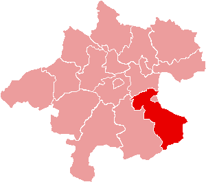
Soubor:Karte Aut Ooe SE.png
Vzhled
Karte_Aut_Ooe_SE.png (300 × 265 pixelů, velikost souboru: 4 KB, MIME typ: image/png)
Historie souboru
Kliknutím na datum a čas se zobrazí tehdejší verze souboru.
| Datum a čas | Náhled | Rozměry | Uživatel | Komentář | |
|---|---|---|---|---|---|
| současná | 23. 6. 2006, 16:17 |  | 300 × 265 (4 KB) | Physchim62 | {{Information |Description=Location of Bezirk Steyr-Land within the Land of Upper Austria |Source=de:Bild:Karte Aut Ooe SE.png |Date=2004 |Author=de:Benutzer:Plp |Permission=GFDL-autho |
Využití souboru
Tento soubor používá následující stránka:
Globální využití souboru
Tento soubor využívají následující wiki:
- Využití na bs.wikipedia.org
- Využití na ce.wikipedia.org
- Využití na de.wikipedia.org
- Využití na es.wikipedia.org
- Využití na fa.wikipedia.org
- Využití na fr.wikipedia.org
- District de Steyr-Land
- Gaflenz
- Modèle:Palette District de Steyr-Land
- Adlwang
- Aschach an der Steyr
- Bad Hall
- Dietach
- Garsten
- Laussa
- Losenstein
- Maria Neustift
- Pfarrkirchen bei Bad Hall
- Reichraming
- Großraming
- Rohr im Kremstal
- Schiedlberg
- Sierning
- Sankt Ulrich bei Steyr
- Ternberg
- Waldneukirchen
- Wolfern
- Weyer (Autriche)
- Využití na fur.wikipedia.org
- Využití na he.wikipedia.org
- Využití na hu.wikipedia.org
Zobrazit další globální využití tohoto souboru.


