
Soubor:Karte A Noe MI 2017.svg

Velikost tohoto PNG náhledu tohoto SVG souboru: 649 × 600 pixelů. Jiná rozlišení: 260 × 240 pixelů | 520 × 480 pixelů | 831 × 768 pixelů | 1 108 × 1 024 pixelů | 2 217 × 2 048 pixelů | 1 050 × 970 pixelů.
Původní soubor (soubor SVG, nominální rozměr: 1 050 × 970 pixelů, velikost souboru: 56 KB)
| Tento soubor pochází z Wikimedia Commons. Níže jsou zobrazeny informace, které obsahuje jeho tamější stránka s popisem souboru. |
Popis
| Popis |
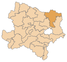
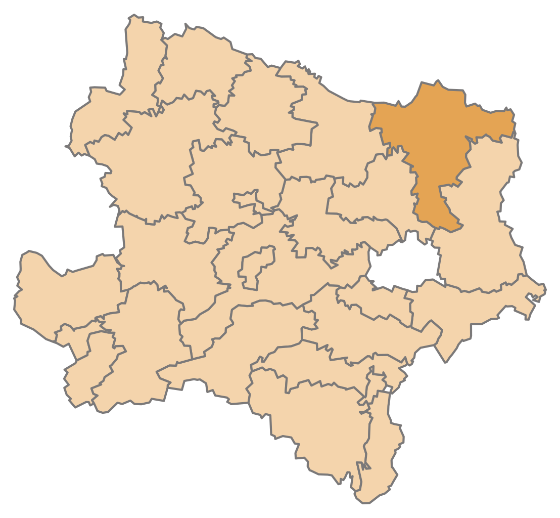
English: Map of the Austrian State Lower Austria, highlighting District Mistelbach (District boundaries valid from 2017)
Deutsch: Karte des österreichischen Bundeslandes Niederösterreich, Bezirk Mistelbach hervorgehoben (Bezirksgrenzen gültig ab Jänner 2017) |
| Datum | |
| Zdroj | Vlastní dílo |
| Autor | AleXXw |
Licence
Já, držitel autorských práv k tomuto dílu, ho tímto zveřejňuji za podmínek následující licence:
Tento soubor podléhá licenci Creative Commons Uveďte autora-Zachovejte licenci 4.0 International
- Dílo smíte:
- šířit – kopírovat, distribuovat a sdělovat veřejnosti
- upravovat – pozměňovat, doplňovat, využívat celé nebo částečně v jiných dílech
- Za těchto podmínek:
- uveďte autora – Máte povinnost uvést autorství, poskytnout odkaz na licenci a uvést, pokud jste provedli změny. Toho můžete docílit jakýmkoli rozumným způsobem, avšak ne způsobem naznačujícím, že by poskytovatel licence schvaloval nebo podporoval vás nebo vaše užití díla.
- zachovejte licenci – Pokud tento materiál jakkoliv upravíte, přepracujete nebo použijete ve svém díle, musíte své příspěvky šířit pod stejnou nebo slučitelnou licencí jako originál.
Historie souboru
Kliknutím na datum a čas se zobrazí tehdejší verze souboru.
| Datum a čas | Náhled | Rozměry | Uživatel | Komentář | |
|---|---|---|---|---|---|
| současná | 12. 11. 2016, 15:05 | | 1 050 × 970 (56 KB) | AleXXw | Colorfix |
| 12. 11. 2016, 14:07 |  | 1 050 × 970 (56 KB) | AleXXw | User created page with UploadWizard |
Využití souboru
Tento soubor používá následující stránka:
Globální využití souboru
Tento soubor využívají následující wiki:
- Využití na de.wikipedia.org
- Bezirk Mistelbach
- Wolkersdorf im Weinviertel
- Laa an der Thaya
- Poysdorf
- Bockfließ
- Mistelbach (Niederösterreich)
- Vorlage:Navigationsleiste Städte und Gemeinden im Bezirk Mistelbach
- Wildendürnbach
- Altlichtenwarth
- Asparn an der Zaya
- Bernhardsthal
- Drasenhofen
- Falkenstein (Niederösterreich)
- Fallbach
- Gaubitsch
- Gaweinstal
- Gnadendorf
- Großebersdorf
- Großengersdorf
- Großharras
- Großkrut
- Hausbrunn
- Herrnbaumgarten
- Hochleithen
- Kreuttal
- Kreuzstetten
- Ladendorf
- Neudorf im Weinviertel
- Niederleis
- Pillichsdorf
- Rabensburg
- Schrattenberg
- Staatz
- Stronsdorf
- Ulrichskirchen-Schleinbach
- Unterstinkenbrunn
- Wilfersdorf (Niederösterreich)
- Ottenthal
- Liste der Wappen im Bezirk Mistelbach
- Liste der Verwaltungsbezirke und Statutarstädte von Niederösterreich
- Denkmalgeschützte Objekte im Bezirk Mistelbach
- Wikipedia:WikiProjekt Österreich/checks/Navis/Niederösterreich 1
- Využití na eo.wikipedia.org
Zobrazit další globální využití tohoto souboru.