Přeskočit na obsah

Soubor:India roadway map.svg

Obsah stránky není podporován v jiných jazycích.
Z Wikipedie, otevřené encyklopedie

Původní soubor(soubor SVG, nominální rozměr: 1 639 × 1 852 pixelů, velikost souboru: 1,11 MB)

Vykreslit tento obrázek v jazyce

Long india borders

Zhodnocení

Obrázek of the year
Obrázek of the year
Featured obrázek

Wikimedia CommonsWikipedie

Tento soubor se účastnil hlasování o Obrázek roku 2006.
Tento obrázek je považován za nejlepší na Wikimedia Commons (Nejlepší obrázky), a tedy splňuje tamější pravidla pro nejlepší obrázky.

 Tento obrázek je považován za nejlepší na Wikipedii v jazyce angličtina (Featured pictures), a tedy splňuje tamější pravidla pro nejlepší obrázky.

Pokud máte nějaký podobně kvalitní soubor, který lze zveřejnit pod vhodnou licencí, určitě ho načtěte, označte a nominujte.

This image was selected as picture of the day on Bengali Wikipedia.

Notes

Depiction of India's borders

  • The territorial boundaries of India are shown as per the actual ground situation in accordance with international practices followed by the United Nations ([1], [2]) and the National Geographic Society ([3], [4])
  • This map is meant to be for illustrative purpose only and is not authenticated by official government sources. Please check the list of sources and references used to create the map for a measure of accuracy and verifiability.
  • The usage of these maps in India, Pakistan and China are governed by different laws that restrict depictions of boundaries other than what is officially recognized by the state. Please check local laws and modify the map accordingly before use.

Explanation of disputed boundaries

  • Boundary of Indian claim : The territory India claims is legally theirs, but the claim is disputed by China and Pakistan.
  • Line of Control/Line of Conflict : The de facto administrative boundary recognised by the international community. This UN ceasefire line is considered as a temporary solution to an ongoing conflict since the departure of the British Raj.

Borders of disputed regions

The depicted extent of the former territory of the British Indian Empire, succeeded by Republic of India, may not be accepted by few countries as legal due to ongoing border disputes:

  • The northern Himalayan region of the disputed territory Indian-administered Kashmir is claimed by India including (Pakistan-administered Kashmir) and the Chinese-occupied territory of (Ladakh plateau). Since 1972, it is divided between all three countries. See also Line of Control and Line of Actual Control.
  • Siachen glacier (shown white) is an actively contested region between India and Pakistan. Since 1984, the region is under Indian control.
  • The northeastern territory of Arunachal Pradesh is almost entirely claimed by China as part of its Tibetan territory.
  • Minor areas of eastern Kashmir's Ladakh division, Himachal Pradesh and Uttarakhand on the Chinese frontier are claimed by China. These areas are under Indian control.
  • A small area of Uttarakhand adjoining the Nepal border along the Sarda river is disputed between the two countries.

For a detailed map of all disputed regions in South Asia, see Image:India disputed areas map.svg

Internal borders

The borders of the state of Meghalaya, Assam and Arunachal Pradesh are shown as interpreted from the North-Eastern Areas (Reorganisation) Act, 1971, but has yet to be verified.

Territorial waters

The limit of the territorial waters of India extends to twelve nautical miles measured from the appropriate baseline. See this for more information.

Titul
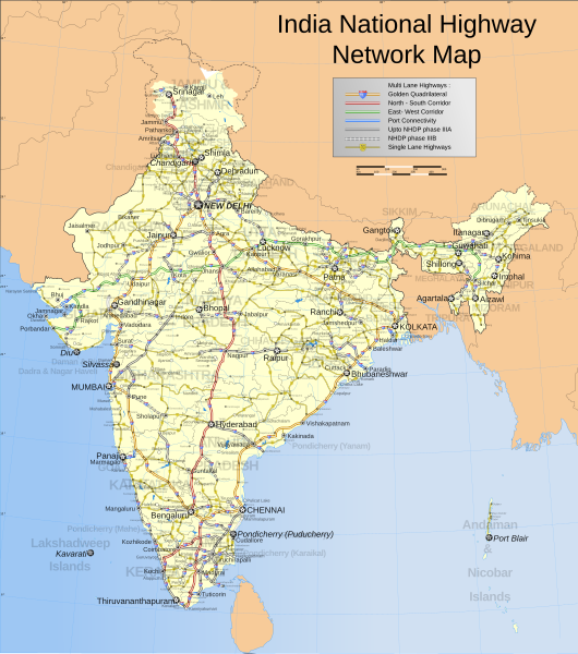
English: India national highway map (detailed)
Français : Inde: carte des routes nationales.
Español: Mapa de las carreteras nacionales de la India.
Popis
English: Map showing the national highway network in India. Includes w:NHDP projects upto phase IIIB which is due to be completed by December 2012. For actual progress of the NHDP refer to the maps below.
Español: Mapa de la red de carreteras nacionales indias. También incluye las vías programadas dentro de la fase actual (IIIB) de construcción, cuya finalización está programada para diciembre de 2012.
Français : Carte montrant le réseau des routes nationales indiennes. Sont aussi incluses les routes programmées dans la phase actuelle (IIIB) de construction, qui doit finir en décembre 2012.
Română: Hartă detaliată a rețelei autostrăzilor naționale indiene.
Українська: Карта національних автомобільних шляхів Індії, станом на 2007 рік.
Map legend
Datum
Zdroj

Vlastní dílo
International Borders: University of Texas map library - India Political map 2001
Disputed Borders: University of Texas map library - China-India Borders - Eastern Sector 1988 & Western Sector 1988 - Kashmir Region 2004 - Kashmir Maps.
State and District boundaries: Census of India - 2001 Census State Maps - Survey of India Maps.
Other sources: US Army Map Service, Survey of India Map Explorer, Columbia University

Map specific sources: NHAI Phase I&II map[5], NHAI Phase IIIA map[6], NHAI Phase IIIB map[7].
Tvůrce
This Image was created by User:PlaneMad.
  • If you are using the image under the creative commons share alike license please credit the photo CC-by-sa PlaneMad/Wikimedia and include a link to this page. No explicit permission is needed from me, but id appreciate an email if my work has been of help to you.
  • If you dont want to release your work under a creative commons license, please mail me at arun.planemad@gmail.com or catch me at my Website to negotiate a custom license as per your needs.
Svolení
(Užití tohoto souboru)
Já, držitel autorských práv k tomuto dílu, ho tímto zveřejňuji za podmínek následující licence:
w:cs:Creative Commons
uveďte autora zachovejte licenci
Dílo smíte:
  • šířit – kopírovat, distribuovat a sdělovat veřejnosti
  • upravovat – pozměňovat, doplňovat, využívat celé nebo částečně v jiných dílech
Za těchto podmínek:
  • uveďte autora – Máte povinnost uvést autorství, poskytnout odkaz na licenci a uvést, pokud jste provedli změny. Toho můžete docílit jakýmkoli rozumným způsobem, avšak ne způsobem naznačujícím, že by poskytovatel licence schvaloval nebo podporoval vás nebo vaše užití díla.
  • zachovejte licenci – Pokud tento materiál jakkoliv upravíte, přepracujete nebo použijete ve svém díle, musíte své příspěvky šířit pod stejnou nebo slučitelnou licencí jako originál.

The frontiers depicted on the Indian maps in Wikipedia are from a neutral point of view and may differ from official government maps of India, Pakistan and China. Please consult local laws governing publication of maps before usage.
 Geotemporal data
Zobrazené datum 2. polovina 20. století a 21. století
Souřadný systém conic
Bounding box
38°04′N 64°13′E / 38.06°N 64.21°E / 38.06; 64.21 38°34′N 100°03′E / 38.57°N 100.05°E / 38.57; 100.05
5°07′N 68°26′E / 5.12°N 68.44°E / 5.12; 68.44 5°36′N 96°52′E / 5.60°N 96.87°E / 5.60; 96.87
Georeferencing Georeference the map in Wikimaps Warper If inappropriate please set warp_status = skip to hide.
 Archival data
Poznámky Part of WikiProject India Maps
Další verze Also available in PNG format at Image:India roadway map.png (not updated).
Simplified version can be found at Image:India simplified roadway map.svg
Map with topographical details Image:India topographical roadway map.svg

Derivative works

Díla odvozená od tohoto souboru:  Golden Quadrilateral.svg

Popisky

Přidejte jednořádkové vysvětlení, co tento soubor představuje

Položky vyobrazené v tomto souboru

zobrazuje

Historie souboru

Kliknutím na datum a čas se zobrazí tehdejší verze souboru.

(nejnovější | nejstarší) Ukázat (10 novějších | ) (10 | 20 | 50 | 100 | 250 | 500).
Datum a časNáhledRozměryUživatelKomentář
současná2. 4. 2021, 11:58Náhled verze z 2. 4. 2021, 11:581 639 × 1 852 (1,11 MB)JoKalliauer1) corrected font-family="'Arial-BoldItalicMT'" and similar to fonts available; 2) put switch at the beginning phab:T279133 3)removed useless clipPaths
27. 12. 2019, 15:11Náhled verze z 27. 12. 2019, 15:111 639 × 1 852 (1 002 KB)नीलमFile uploaded using svgtranslate tool (https://tools.wmflabs.org/svgtranslate/). Added translation for hi.
19. 8. 2018, 00:04Náhled verze z 19. 8. 2018, 00:041 639 × 1 852 (909 KB)CbyneorneFixed the spelling of the capital of Mizoram.
2. 4. 2007, 08:14Náhled verze z 2. 4. 2007, 08:141 639 × 1 852 (909 KB)GmaxwellPlease do not include copyrighted fonts in your SVGs.
2. 4. 2007, 08:13Náhled verze z 2. 4. 2007, 08:131 639 × 1 852 (909 KB)GmaxwellPlease do not include copyrighted fonts in your SVGs.
9. 1. 2007, 09:33Náhled verze z 9. 1. 2007, 09:331 639 × 1 852 (1 001 KB)Planemaduttaranchal>uttarkhand, minor color corrections and numbering correction
13. 11. 2006, 19:04Náhled verze z 13. 11. 2006, 19:041 639 × 1 852 (1 018 KB)Planemaddesignation for all highways
9. 11. 2006, 12:59Náhled verze z 9. 11. 2006, 12:591 639 × 1 852 (865 KB)Planemadupdated karnataka city spellings, added nh 110 112 113 114 116 117 119 121 123 153 154 155 224 225 226 227, corrections in north east states
6. 11. 2006, 21:31Náhled verze z 6. 11. 2006, 21:311 639 × 1 852 (844 KB)Planemadnh designation markers on nhdp highways, rivers enabled, lightened state names, 3d locators for capitals and major cities, minor corrections north east areas
15. 10. 2006, 20:01Náhled verze z 15. 10. 2006, 20:011 639 × 1 852 (718 KB)PlanemadIncluded Nhdp phase IIIA, Changed stroke styles for highways, changed marker locators, added state names, included road legend, added more cities and towns, corrections
(nejnovější | nejstarší) Ukázat (10 novějších | ) (10 | 20 | 50 | 100 | 250 | 500).

Tento soubor nepoužívá žádná stránka.

Globální využití souboru

Tento soubor využívají následující wiki:

Zobrazit další globální využití tohoto souboru.

Metadata