
Soubor:EU Members Candidates 2004 2007.png

Původní soubor (1 360 × 1 245 pixelů, velikost souboru: 25 KB, MIME typ: image/png)
| Tento soubor pochází z Wikimedia Commons. Níže jsou zobrazeny informace, které obsahuje jeho tamější stránka s popisem souboru. |

|
K tomuto obrázku existuje vektorová verze (v SVG). Pokud je lepší, používejte raději tu.
File:EU Members Candidates 2004 2007.png → File:EU27-2012-candidate countries map.svg
Podrobnější informace o vektorové grafice najdete na stránce Commons:Transition to SVG. Také si můžete přečíst informace o podpoře formátu SVG v MediaWiki. |
 |
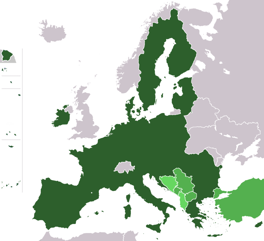
Map of the European Union with (1) member states after the 2013 enlargement, (2) candidate countries Turkey, FYR Macedonia, Montenegro, Serbia and Iceland, (3) at left (some of) the territories of France, Portugal and Spain, and (4) the potential member states (is an official EU-status, see EU-website) of the European Union (Albania, Bosnia-Herzegovina).
- France – Overseas departments (Départements d'outre-mer)
- on the North-East coast of South America:
- French Guiana
- islands in the Caribbean:
- Guadeloupe (with Saint Martin and Saint-Barthélemy)
- Martinique
- islands in the Atlantic Ocean in North America:
- Saint Pierre and Miquelon
- islands in the Indian Ocean:
- Réunion
- Mayotte - not shown
- on the North-East coast of South America:
- Portugal
- islands in the Atlantic Ocean:
- Azores
- Madeira
- islands in the Atlantic Ocean:
- Spain
- islands in the Atlantic Ocean:
- Canary Islands
- cities on the Coast of North Africa:
- Ceuta
- Melilla
- islands in the Atlantic Ocean:
Author: wiki-vr 19:38, 26 Mar 2005 (UTC)
Based on: http://en.wikipedia.org/wiki/Image:Europe_blank_map.png
| Wiki-vr, autor tohoto díla, jej uvolnil jako volné dílo, a to celosvětově. V některých zemích to není podle zákona možné; v takovém případě: |
Historie souboru
Kliknutím na datum a čas se zobrazí tehdejší verze souboru.
| Datum a čas | Náhled | Rozměry | Uživatel | Komentář | |
|---|---|---|---|---|---|
| současná | 10. 2. 2020, 21:05 | | 1 360 × 1 245 (25 KB) | Hektor Absurdus | Iceland is no longer a candidate state |
| 7. 2. 2020, 20:44 |  | 1 360 × 1 245 (25 KB) | Hektor Absurdus | - UK | |
| 25. 1. 2014, 01:23 |  | 1 360 × 1 245 (24 KB) | Hektor Absurdus | + Croatia, updated candidates | |
| 1. 2. 2008, 10:54 |  | 1 360 × 1 245 (28 KB) | Xiong Chiamiov | optimized using optipng | |
| 25. 1. 2007, 11:28 |  | 1 360 × 1 245 (81 KB) | Hoshie | added Ceuta, Melilla. Sint Maarten, the SBAs, and Crown Dependencies aren't in EU. | |
| 1. 1. 2007, 05:21 |  | 1 360 × 1 245 (81 KB) | Cassini83 | ||
| 29. 12. 2006, 14:05 |  | 1 360 × 1 245 (81 KB) | Palazov~commonswiki | add Montenegro | |
| 29. 12. 2006, 11:35 |  | 1 360 × 1 245 (81 KB) | Palazov~commonswiki | Author: wiki-vr 19:38, 26 Mar 2005 (UTC) Based on: http://en.wikipedia.org/wiki/Image:Europe_blank_map.png {{PD-user|Wiki-vr}} Category:Maps of the European Union | |
| 25. 5. 2006, 22:25 |  | 1 360 × 1 245 (59 KB) | Wiki-vr | all the enlargements to come, hues of green | |
| 24. 3. 2006, 01:11 |  | 1 360 × 1 245 (71 KB) | Valentinian | All other borders inside the union were already removed, so removed the Danish-German one as well. Minor fixes in North Jutland (Denmark). |
Využití souboru
Tento soubor nepoužívá žádná stránka.
Globální využití souboru
Tento soubor využívají následující wiki:
- Využití na en.wikipedia.org
- Využití na pl.wikipedia.org