
Soubor:Balkans 6th century.svg

Velikost tohoto PNG náhledu tohoto SVG souboru: 800 × 431 pixelů. Jiná rozlišení: 320 × 173 pixelů | 640 × 345 pixelů | 1 024 × 552 pixelů | 1 280 × 690 pixelů | 2 560 × 1 381 pixelů | 1 400 × 755 pixelů.
Původní soubor (soubor SVG, nominální rozměr: 1 400 × 755 pixelů, velikost souboru: 1,83 MB)
| Tento soubor pochází z Wikimedia Commons. Níže jsou zobrazeny informace, které obsahuje jeho tamější stránka s popisem souboru. |
Popis
| Popis |
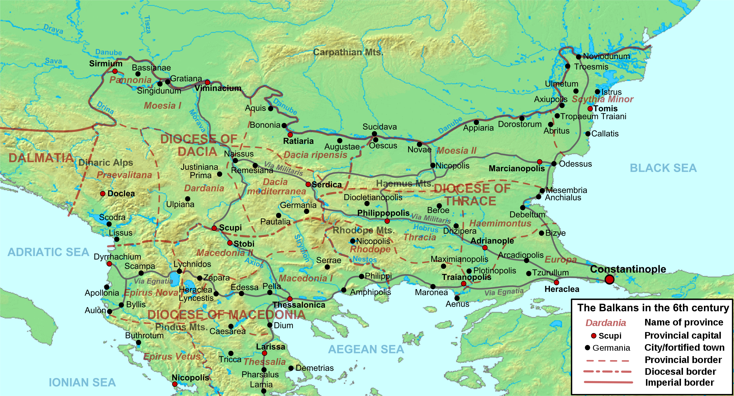
Deutsch: Die nördliche Balkanhalbinsel in der Spätantike (6. Jahrhundert), mit den spätrömischen Provinzen, Hauptsiedlungen und Straẞen.
English: Map of the northern Balkans in the 6th century AD, with the Roman provinces, major settlements and roads.
Français : Carte des Balkans septentrionaux au VIe siècle, à la veille de l'arrivée des Slaves, avec les provinces romains, les villes et les routes les plus importantes. |
| Datum | |
| Zdroj |
Vlastní dílo based on:
|
| Autor | Cplakidas |
| Další verze |
[]
|


Licence
Já, držitel autorských práv k tomuto dílu, ho tímto zveřejňuji za podmínek následujících licencí:
Tento soubor podléhá licenci Creative Commons Uveďte autora-Zachovejte licenci 3.0 Unported
- Dílo smíte:
- šířit – kopírovat, distribuovat a sdělovat veřejnosti
- upravovat – pozměňovat, doplňovat, využívat celé nebo částečně v jiných dílech
- Za těchto podmínek:
- uveďte autora – Máte povinnost uvést autorství, poskytnout odkaz na licenci a uvést, pokud jste provedli změny. Toho můžete docílit jakýmkoli rozumným způsobem, avšak ne způsobem naznačujícím, že by poskytovatel licence schvaloval nebo podporoval vás nebo vaše užití díla.
- zachovejte licenci – Pokud tento materiál jakkoliv upravíte, přepracujete nebo použijete ve svém díle, musíte své příspěvky šířit pod stejnou nebo slučitelnou licencí jako originál.

|
Tento dokument smí být kopírován, šířen nebo upravován podle podmínek Svobodné licence GNU pro dokumenty verze 1.2 nebo libovolné vyšší verze publikované nadací Free Software Foundation. Dokument nemá neměnné části ani texty na předním či zadním přebalu. Kopie textu licence je k dispozici v oddíle nazvaném GNU Free Documentation License. |
Můžete si zvolit libovolnou z těchto licencí.
Historie souboru
Kliknutím na datum a čas se zobrazí tehdejší verze souboru.
| Datum a čas | Náhled | Rozměry | Uživatel | Komentář | |
|---|---|---|---|---|---|
| současná | 11. 5. 2012, 11:52 | | 1 400 × 755 (1,83 MB) | Cplakidas | corrected locations of Thracia and Haemimontus, minor tweaks elsewhere |
| 7. 1. 2012, 22:27 |  | 1 400 × 755 (1,91 MB) | Cplakidas | Left-over names to paths | |
| 1. 3. 2010, 22:29 |  | 1 400 × 755 (2,1 MB) | Cplakidas | names to paths | |
| 1. 3. 2010, 22:20 |  | 1 400 × 755 (1,08 MB) | Cplakidas | {{Information |Description={{en|1=Map of the northern Balkans in the 6th century AD. Geophysical map taken from from [http://www2.demis.nl/mapserver/mapper.asp DEMIS Mapserver], which are public domain, other wise self-made. Sources: [http://soltdm.com/so |
Využití souboru
Tento soubor používají následující 4 stránky:
Globální využití souboru
Tento soubor využívají následující wiki:
- Využití na ar.wikipedia.org
- Využití na azb.wikipedia.org
- Využití na be.wikipedia.org
- Využití na bg.wikipedia.org
- Využití na bs.wikipedia.org
- Využití na de.wikipedia.org
- Využití na el.wikipedia.org
- Využití na en.wikipedia.org
- History of Albania
- 593
- Maurice (emperor)
- Moesia
- Dardani
- Serbia in the Middle Ages
- Pannonia (Byzantine province)
- Dacia Ripensis
- Dacia Mediterranea
- Dacia Aureliana
- Diocese of Dacia
- Praevalitana
- Peter (curopalates)
- Maurice's Balkan campaigns
- Dardania (Roman province)
- Ratiaria
- Via Militaris
- Comentiolus
- Albania under the Byzantine Empire
- List of ancient cities in Thrace and Dacia
- Justin (consul 540)
- Priscus (magister militum)
- Europa (Roman province)
Zobrazit další globální využití tohoto souboru.